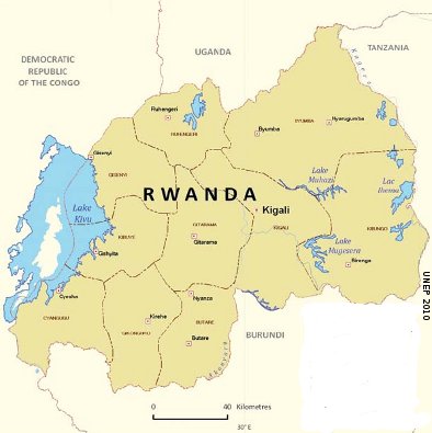
Rwanda’s topography is considered hilly and mountainous with an altitude ranging 900 m and 4.507 m (average 1700 m) and a tropical temperate climate due to this high altitude. The average annual temperature ranges between 16 and 20 degrees without significant variation with average rainfall of about 1,250 mm per annum.
The country’s hydrology is characterized by dense network of lakes, rivers and wetlands. Water is without any doubt Rwanda’s most valuable natural resource, approximately 210,000 ha 8% of the entire country is under water.
The country is divided into two major drainage basins, the Nile basin to the east and the Congo basin to the west. The Congo basin covers 33% of Rwanda and handles 10% of all national waters and the Nile basin covers 67% and delivers 90% of national water needs. The waters of the Nile basin flow out through the Akagera river system which contributes 8 to 10% to the Nile drainage system.
Climate in Rwanda
Rwanda has a temperate tropical highland climate, with lower temperatures than is typical for equatorial countries. Due to its high altitude, its temperature and rainfall are more moderate than the surrounding hot and humid equatorial regions. Rwanda’s average temperature varies according to its topography. Low temperatures are observed in the regions of high altitude (Gisenyi, Ruhengeli and Byumba) with average temperatures ranging between 14 and 18°C. Gikongoro, Butare, Kibuye and Kamembe experienced temperature ranging between 19 and 20°C. The average of 21 to 23°C is observed at Kigali, Gitarama and Rwamagana.
The country’s rainfall is varying according to four seasons: A short rainy season from September to November and a longer season between March and May and two dry periods. Some parts of Rwanda have experienced unusual irregularities in climate patterns including variability in rainfall frequencies and intensity. The livelihoods of people in Rwanda are dependent on agriculture. Whilst reduced rainfall can affect farm yields, extreme and torrential downpours can accelerate the process of soil erosion.
Possible consequences of the climate change
Increased vulnerability under climate change is expected to result in:
-
Extreme flood and drought events are estimated to reduce long-term growth in the region by about 2.4% of GDP per annum.
- Increased average temperatures and changes in annual and seasonal rainfall will be felt across key economic sectors, most important affecting agricultural production, energy use, infrastructure, biodiversity and ecosystem.
WACDEP implementation
WACDEP should strengthen Rwanda’s already existing and proposed climate change adaptation and related intervention activities identified in the Strategic Document on Poverty Reduction, the Initial National Communications (INC), the National Capacity Self Assessment (NCSA), the National Adaptation Programme of Action (NAPA), and the ongoing development process of the Second National Communications (SNC). WACDEP can further focus on proper climate change adaptation and mitigation policies are critical to environmental protection and planning and should provide resources to support effectively the implementation of land management in Rwanda Programmes should aim to reduce land degradation especially soil erosion in an event of increased rainfall due to the hilly nature of the country. Flood adaptation measures should ale be in place.
