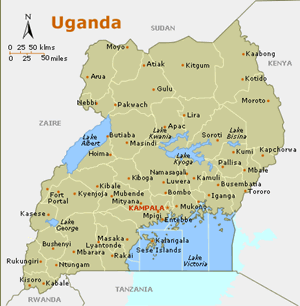
The country, which lies across the equator, is divided into three main areas—swampy lowlands, a fertile plateau with wooded hills, and a desert region.
The Nile Basin constitutes about 98 percent of the total area of the country, while a fringe of about 4 500 km2 along the country’s border with Kenya belongs to the Rift Valley Basin.
Uganda has an equatorial climate with small regional variations in annual temperature and humidity
Uganda has substantial natural resources, including fertile soils, regular rainfall, and sizeable mineral deposits of copper and cobalt. The country has largely untapped reserves of both crude oil and natural gas.
Key Water Issues and Challenges
- Draining of wetlands for agricultural use
- Deforestation
- Overgrazing;
- Soil erosion
- Water hyacinth infestation in Lake Victoria
- Heat waves, droughts, floods and storms.
Contact GWP Uganda
Dr. Jackson Twinomujuni
GWP Regional Steering Committee Member
Chair of Uganda Country Water Partnership
Email: jk.twinomujuni@gmail.com
More Information
AQUASTAT -FAO's Information System on Water and Agriculture http://www.fao.org/nr/water/aquastat/main/index.stm
UN-Water Statistics http://www.unwater.org/statistics_KWIP.html
Source: www.cia.gov; http://data.worldbank.org; www.unwater.org
